
The severn bridge, in awful weather yesterday. I followed the signs of the cycle path over the bridge which somehow took me to the path on the faraway west side, as opposed to the east side i approached from. On the other side, it’s not at all obvious where to go. It’s all motorway and fast roads, much like the forth bridge.
What else happened yesterday? I thought i’d make much better progress without big hills, but the weather and some wrong turnings put paid to that. On my ride to work i do maybe 14mph average. On long but non stop training rides it was 12mph or 9mph against a strong gale. But, including meal stops, and many navigation stops i’m managing about 7.5mph overall. When i’m moving, the average speed is about 10.5. But all the stops add up in a big way.
Ho hum, downpour has finished. I’m going to wait for a bit to let the water drain a bit and see how things look.
Category: Uncategorized
Can’t rain all the time?
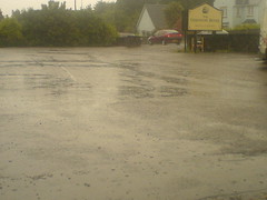
Was just about to leave when the light drizzle turned into a full on downpour. I’m currently sitting under a sun parasol thing (the irony!) outside the hotel waiting to see if it’s going to subside at all. Sigh.
Plan
Just watched forecast. Not good generally. More excitingly, it turns out there was a severe weather warning issued today for the area i cycled through. Not having much luck with the old british weather. Anyhow, provisioak revised plan for tomorrow is to get up early, verify the forecasts claim of a mostly dry morning in this specific area, and then dart 30m up the road to ross on wye. Might have to stay put there if the weather is bad.
Begone Bristol
Bristol is not my favourite place. Today it rained since noon until i arrived at 6pm. All my riding clothes are soaked. Will look at forecast and see if it’s sane to ride tomorrow. I have a towel rail, a hairdryer and some towels to work a dehydration miracle with.
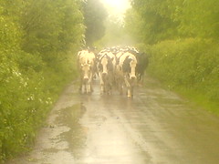
Ah, the photo. After hours in the rain, several wrong turning, too much busy bristol traffic and one close shave with a van, i wasn’t in the best of moods. The directions said ‘turn into the northward lane’. When i did, i was met with this sight blocking the road. I had to laugh.
Cheddar gorge
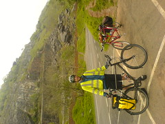
Prob the photo is rotated, still haven’t figured fix for that! After the first 3 days, Cheddar gorge seemed more like a gentle incline! The first two corners were steeper but the rest was a spinning slope up to about 220m. It was like some kind of ‘well done, you passed the test’ thing. 🙂 i’m having lunch in chew magna. Not long since 2nd breakfast, but places stop serving at 2 so i need to refuel before then. Target tonight is the Severn Bridge and Chepstow.
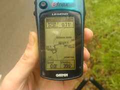
Epic gps fail
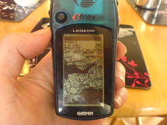
I don’t know why, but it appears that the routes i have on my gps for day 4 to day 7 are just copies of day 3’s route. I meant to verify each and every route once i’d put it onto the gps but ran out of time. It’s not the end of the world. I still have my road map, plus google maps on my phone. But it is a big pain.
I’m in Cheddar just now having food before the climb up the gorge. Much flatter today as promised, and i’ve been whizzing along at 18mph or so.
Thanks
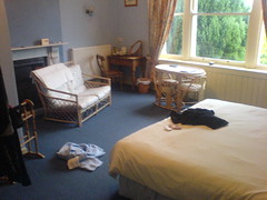
Just wanted to say thanks for all the comment, emails, texts and sponsorship over the last few days. It’s great to hear from people, especially when i’m in the middle of nowhere at the time! ?Mostly for my own recollection, here’s what my days look like: ?0745 Get up, watch weather forecast.?0800 Breakfast. Cereal, full english, lots of toast and tea.?0830 Review route, get changed into cycling gear, put on suncream and repack panniers.?0900 Start pedalling. Repeat until hungry.?1130 Stop for tea and pancake stack.?1200 Lots more pedalling, some pushing! ?1330 Stop for soup, cake and tea.?1415 Pedal pedal. Take rain gear off and on several times.?1715 Brief mega snack from my panniers. Avoids the late afternoon crunch which i noticed on day 2.?1800-1900 Arrive at bnb, have shower.?1930 eat dinner. This has been tesco’s pasta on day 1, fish and chips on day 2 and a 3 course sit down meal tonight. ?2030 wash cycling gear in sink, dry using the magic travellers method involving rolling in a towel.?2100 stretches and a bit of yoga. ?2130 pre bed snack, some flapjacks or nuts and hot chocolate. Plus lots of texting and internetting. Mobile internet is so cool. Opera mini is particularly impressive, but the phone in general is a really capable device. After typing all these blog posts on my phone keypad, i think i can probably text as fast as am average 14 year old now! ?2230 and so to bed. On day 1 i kept dreaming about pedalling and turning corners, but hopefully my brain is over that now. 🙂 ?Oh, photo is of my rather spacious room in the bnb which turned out to be a mansion!
Day 3 retro
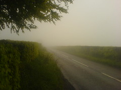
Hehe, i just did Cornwall and Devon, woot! And furthermore tomorrow has all of the flat. Well, possibly all of the rain too, but you can’t have it all it seems.?Anyhow, the photo is of the Brendon Hills in Exmoor during today’s ‘can’t see a thing’ phase. Glad to have made it down to sea level after that somewhat exciting excursion.?The day started with me retracing my step back from the farm into torrington. Somehow the road didn’t seem as long as it did yesterday and the hills weren’t quite as steep, hmm. Then i followed the ctc route up to Atherton, featuring today 41mph highlight. During that, and subsequent bumpier descents i began to fully appreciate the art of good bicycle design – something which worked fine at low speed could become a nightmare at high speeds.?I stopped in a tea shop in south molton for an extra breakfast. I’m a bit shocked by how much i’ve been physically able to eat today. Next was the dreech and lonely grind up 400m into Exmoor. Once up, things got faster for a while, and i got lots of aero bar time despite the rain cloud i was in. More descents and climbs were the pattern for the day. I even outran some cars on the descent into Enmore. :)?The gps has saved my bacon lots today. I’d be so screwed without it. On the odd occasion i go the wrong way anyway but the gps quickly makes it apparent that i’m headed in the wrong way. Them satellites sure do rock.
Head in the clouds.
Reaching 400m for the second time today. However, the cloud base was at about 300m which meant visibility was down to maybe 50m for a while. Fortunately it was quiet and you can hear cars coming way in advance so i could duck off the road if i was coming near a bend.?I’m currently standing at the bottom of the last steep hill of day 3. Woo, no more hills after this for a while. I think it’d be a stretch to say that i’m going to appreciate or enjoy the hill in any way however! I’m beginning to wonder how many of the 14 day lejog’ers i found on the internet were doing it solo and unsupported. Still, i’m still going and basically don’t feel bad at all. I could do with having more patience i think! That’s about all.
Exmoor
Exmoor, aka the middle of nowhere. Given that the map was green in this area, i thought the whole thing was forest. But, no, it is plain old full of nothing moorland. And, having made it up the 400m ascent after north molton I was rewarded by . . . being in a cloud. On with full waterproofs for the first time this trip. But today has seen fewer short sharp hills and more rolling countryside. The one short sharp climb was made more fun by having a huge two stage sheep lorry attempt to get down into the village. In the end, the lorry driver had to get out and manouver a car belonging to a clueless local back down the hill in reverse. ?H’ve stopped for lunch in a lovely tea room in Winsford. However i’ve come to realise that any village which has a stream running through it is usually followed by a big climb. Time to find out!